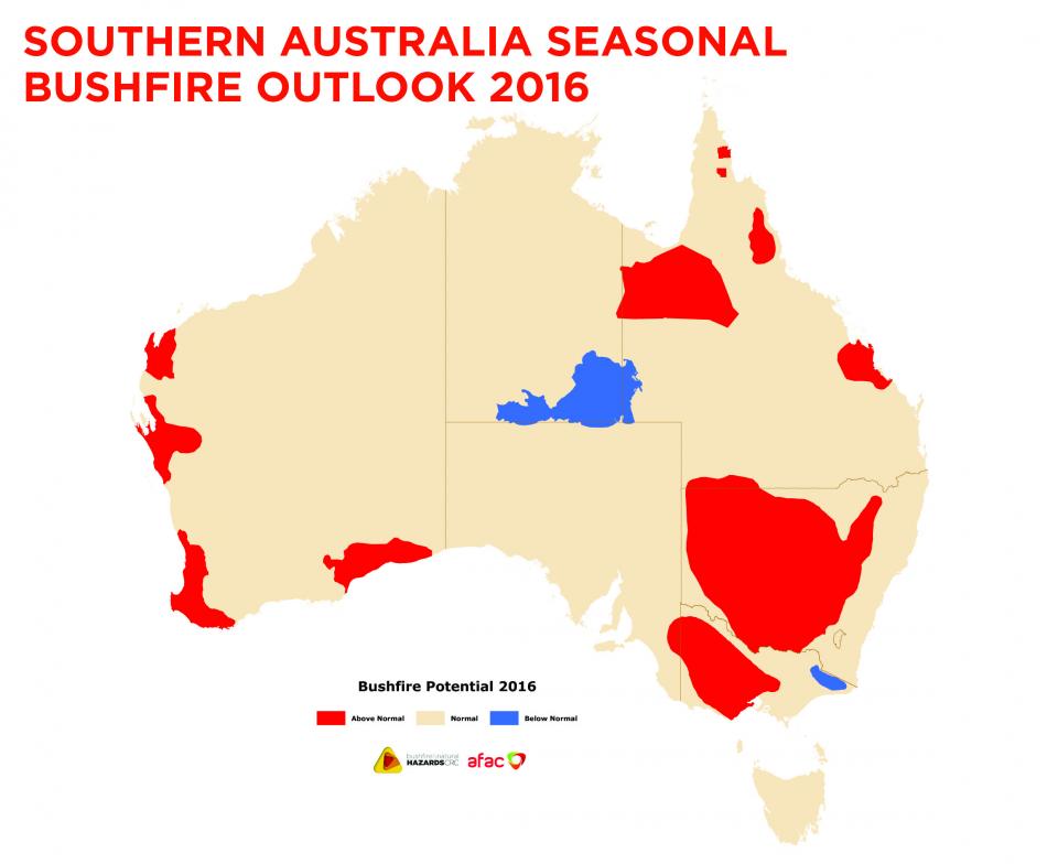
Southern Australia Seasonal Bushfire Outlook 2016
Published Date: 01 Sep 2016
Summary
The Southern Australia Seasonal Bushfire Outlook 2016 shows a mixed picture for fire potential, with the exceptionally warm and wet conditions through winter likely to continue into spring.
View the Bushfire and Natural Hazards website
Download the Southern Australia Seasonal Bushfire Outlook.

The Southern Australia Seasonal Bushfire Outlook 2016 shows a mixed picture for fire potential, with the exceptionally warm and wet conditions through winter likely to continue into spring. Every month of 2016 has seen Australia's national mean temperature above the long term average, although with the breakdown of El Niño, rainfall has been above average across most of the country - winter has seen the second wettest on record. The pattern of heavy rainfall following a strong El Niño is not uncommon and is tied to the warming of ocean waters around Australia. Spring is likely to see above average across most of the country, with the exception of parts of New South Wales and Queensland. There is a higher chance of above average rainfall across northern and eastern Australia.
The Seasonal Bushfire Outlook for southern Australia is used by fire authorities to make strategic decisions on resource planning and prescribed fire management for the upcoming fire season. The outlook is developed at an annual workshop convened by the Bushfire and Natural Hazards CRC and the Australasian Fire and Emergency Service Authorities Council.
At the 2016 workshop in Brisbane in August, the Outlook was assessed and a range of broad climate and resource factors were considered.
The workshop discussed the weather, landscape conditions and cross-border implications leading into summer and determined areas that had the potential for a fire season that was above normal or below normal.
The Outlook map shows the bushfire outlook for southern Australia through to the end of 2016. This map has been combined with the outlook for the northern Australia bushfire season, which was released at the beginning of July, to show the areas of fire potential for all of Australia. (See Hazard Note 18, July 2016).
This Outlook will be reviewed towards the end of spring to take into account the impacts of actual temperatures and rainfall in the lead up to summer.


